
Add impact intelligence to your product, without building a weather team
Your customers want to know what the weather will do to them, and some of your competitors now bundle basic weather for free. A weather feed doesn't answer that. Impact does: risk scores, alerts and ETAs your customers act on, powered by WeatherOptics.
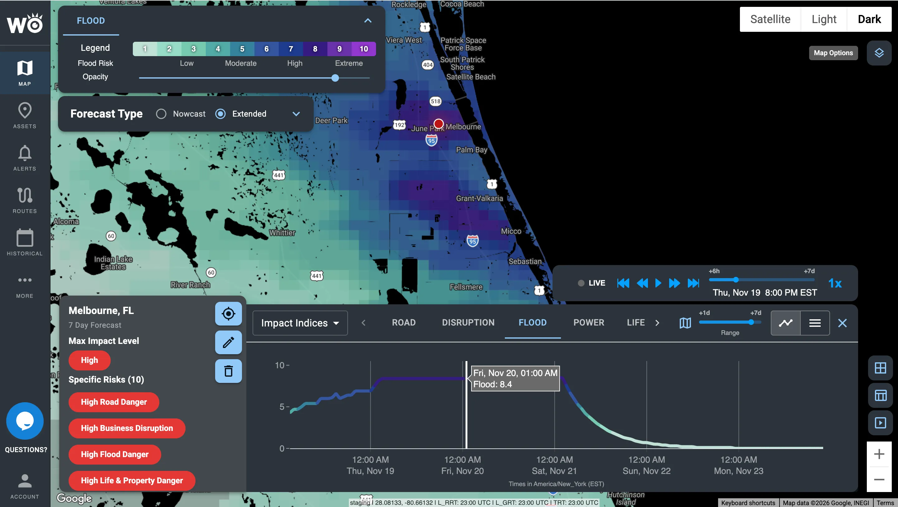
Flood Risk Index data, scored 0 to 10 and ready for your own product through the API and map tiles.
What will the weather do to my customers?
Your customers don't need another weather map. They need to know what the weather will do to their trucks, shipments and sites. We give you that answer to put in front of them, before, during and after every storm.
Days ahead: plan
Impact forecasts up to 7 days out for every route, vehicle and site your customers track.
Hours ahead: act
Alerts and weather-adjusted ETAs your customers act on, delivered by webhook inside your product.
During: respond
The next six hours in 15-minute steps, plus live road closures, truck restrictions and cameras.
After: recover and prove
Power outages, damage reports and closures, so your customers can see what actually happened.
Our own AI weather model, turned into impact
HYPERR, our own AI weather model, forecasts at 3-km resolution every 15 minutes. Our engine combines it with roads, terrain, rivers and the power grid, and 15+ years of what weather has actually done, to produce impact forecasts your customers can act on. Every data family is available through the API, webhooks and map tiles.
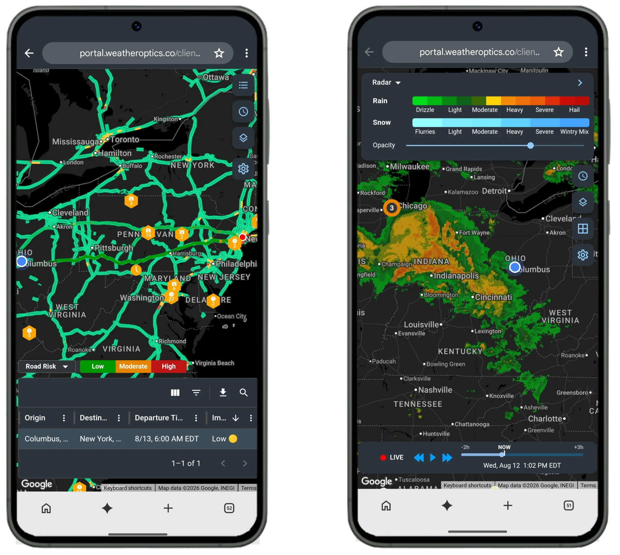
On any screen. Road risk along a route and live radar, on mobile.
Everything your product needs, through one API
Any data family, delivered the way your product works.
Hyperlocal forecasts
Hyperlocal Weather from our own AI weather model, down to an exact location: 3-km resolution, every 15 minutes, up to 7 days.
Impact scores
Impact Models score how badly the weather will hit each route, vehicle and site, from the Road Risk Index to the Power Outage Index.
Major event monitoring
Critical Events outlines every major weather event, with an AI briefing in plain language.
What actually happened
Impact Reports confirm the impact: Live Road Status, power outages, damage reports and more.
Weather-adjusted ETAs
ETAs that already account for the weather along each route, ready to show in your product.
Built for developers
REST APIs, webhooks and map tiles with 99.9% uptime.
Proven at scale
Trucks run on WeatherOptics alerts. Our alerts already reach drivers inside the platforms they use.
Connected vehicles our models learn from. A different count from the 150,000+ trucks that run on our alerts.
Lower forecast error than NOAA models, in a 12-month study.
Trusted across trucking, logistics and retail








What your customers see inside your product
The same impact data, delivered in the shape your product needs.
An ETA with the weather already in it
Weather-adjusted ETAs and route risk on every load, up to seven days out.
A driver alert before the hazard
Truck-by-truck alerts delivered in the cab through your device.
Risk layers on your basemap
Road risk, power outage, flood and wildfire layers at 3-km resolution.
Sites ranked by what the storm will do
0 to 10 Impact Risk Scores for every site and region your customers run.
Already inside the platforms fleets use







Get started
- Book a demo with our partnerships team
- Run a 30-day pilot through the API
- Request our forecast accuracy reports
See what your customers would have seen
Send us a handful of past storms or incidents from your customers. We'll show you what we would have flagged, and how far ahead.
Become a WeatherOptics insider
Get insights on weather intelligence and product updates delivered to your inbox.