
Hurricane Isaias Threatens the Northern Gulf Coast With Life-Threatening Surge, I-10 Closures and Widespread Outages
Isaias is expected to make landfall on the northern Gulf Coast Friday evening. See the WeatherOptics impact forecast for roads, flooding, wind and power.
Isaias formed in the Gulf Wednesday morning and has already grown into a Hurricane. It is poised to make landfall along the northern Gulf Coast late Friday night.
Just three days ago, Isaias was a disorganized mass of thunderstorms over the Bay of Campeche. It has since organized into a strengthening Hurricane with a well-defined circulation. Above-normal sea-surface temperatures and a break in wind shear should allow it to keep strengthening Thursday through Friday morning.
Isaias was upgraded to a hurricane at 11:30 PM ET Oct 7.
Isaias is the Atlantic basin's first hurricane of the season. It was hours away from tying the 121 year-old record for the latest-forming first hurricane, originally set October 8, 1905
Storm Track and Latest Forecast
Isaias is moving northeast and will gradually turn north through the end of the week as a trough over Texas pulls it toward the northern Gulf Coast. Landfall is expected late Friday night or early Saturday morning.
Where it comes ashore is still uncertain. There is a wide along-track spread in possible landfall locations: deterministic models such as the GFS and HFS take a more westerly track than AI ensembles such as Google DeepMind's ensemble (GDMI). Some deterministic runs are also stronger, showing rapid intensification on Thursday and potentially reaching major hurricane status.
AI models generally handle track better than intensity and the system has intensified along the stronger end of the guidance envelope, so rapid intensification into a Category 3 hurricane cannot be ruled out. The official NHC forecast issued at 4am CT Thursday morning projects the storm to peak at a high end Category 2 storm with sustained winds of 110 mph by late Thursday night.
Even so, increasing wind shear from the approaching trough on Friday suggests Isaias will make landfall as a Category 1 or Category 2 hurricane under current worst-case projections.
That shear will also spread the storm's wind field out. Strong tropical-storm-force winds will extend far from the center, especially on the north and east sides toward central Alabama, Florida, and southern Georgia.
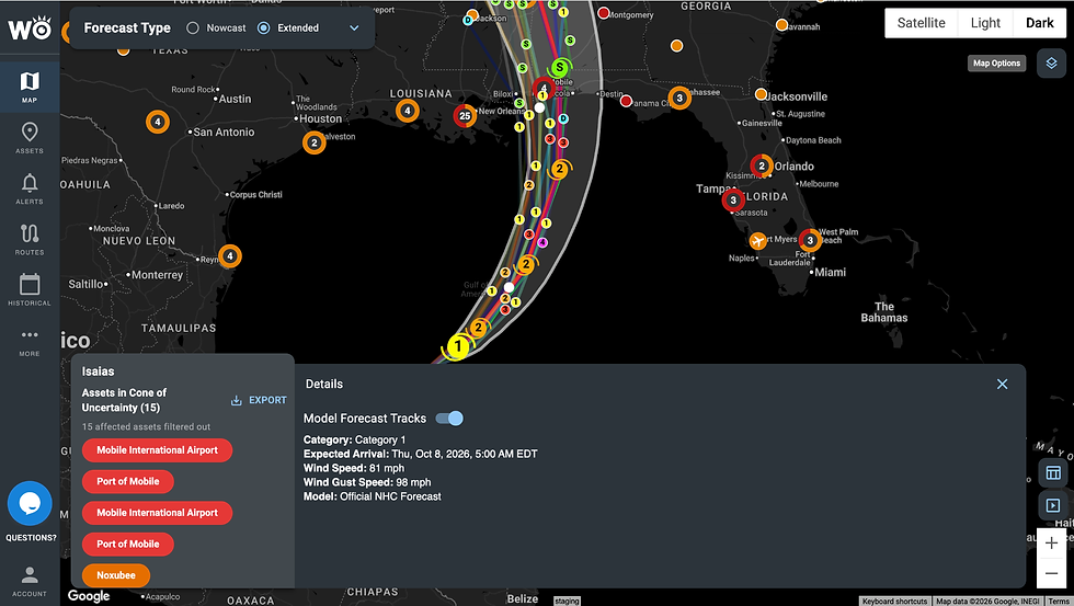
Why Impacts Will Reach Far Beyond Landfall
Mobile, AL is currently forecast to be the hardest hit, though that may change as confidence in the track and intensity grows. What will not change much is the storm's size. Its large wind field will continue to grow ahead of making landfall, with tropical storm-force winds expected to extend as much as 170 mi from its center. This will cause dangerous storm surge, destructive winds, and flooding to reach areas far away from landfall, regardless of how strong Isaias is when it comes ashore
The threat of widespread power outages, inland and storm-surge flooding, destructive winds, and impassable roads is driving WeatherOptics Impact Risk Scores to extreme levels near Isaias’s forecast landfall location. By combining hyperlocal weather forecasts with non-weather geospatial data, these scores predict how the storm will affect key business operations—and point to potentially severe disruptions in the hardest-hit areas.
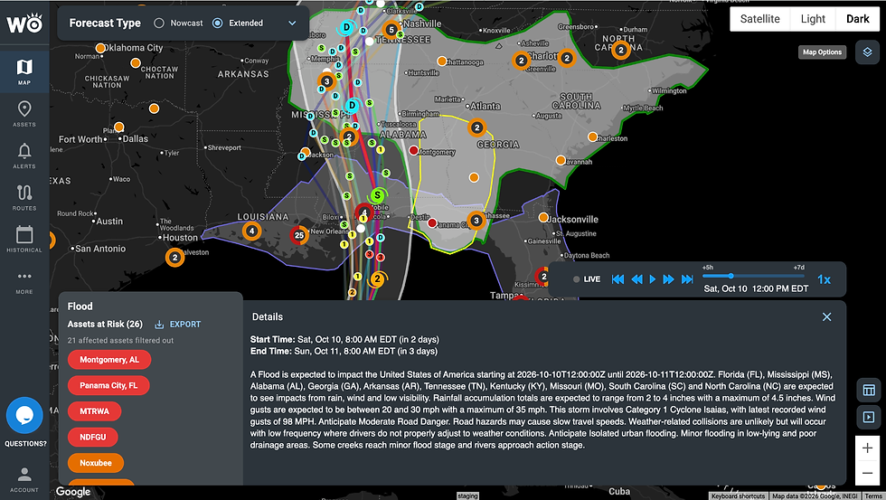
Key Impacts Across the Northern Gulf Coast
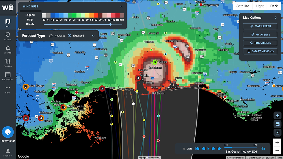
01 Destructive Winds
Timing: Winds build along the coast through Friday and peak Friday night into early Saturday near landfall.
Winds: Gusts of 20–55 mph are expected across much of the region, with peak gusts up to 100 mph near the core. The strongest gusts are currently focused on Mobile Bay, coastal Baldwin County and Pensacola.
Reach: Because of the broad wind field, strong tropical-storm-force winds will extend east across the Florida Panhandle and into southern Georgia and west across Coastal Mississippi.
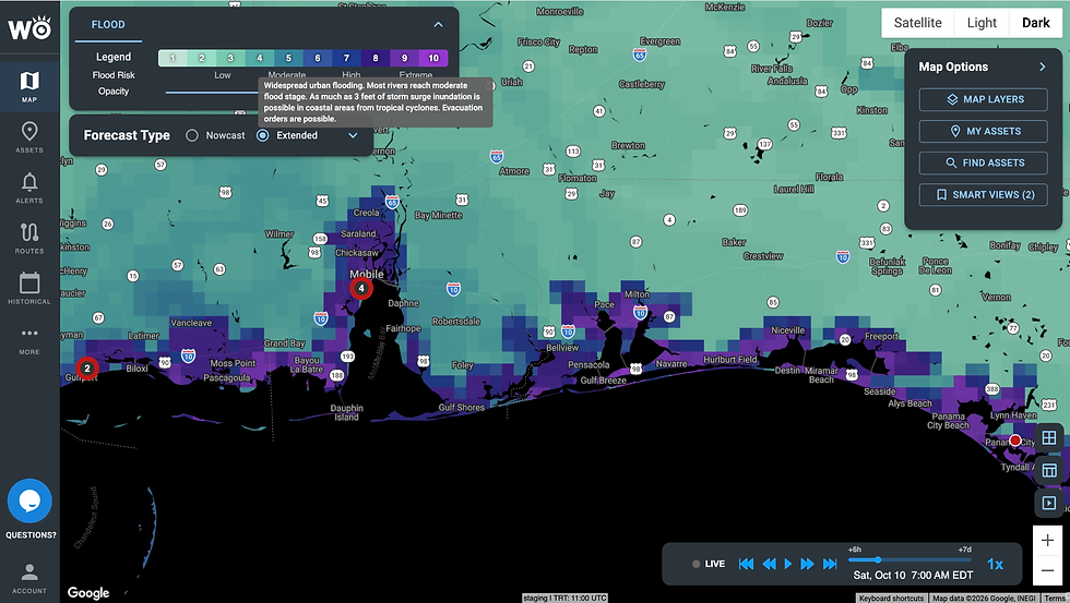
02 Storm Surge and Flooding
Storm Surge: Surge will be extremely dangerous with this system because of its large wind field. The WeatherOptics Flood Index shows inundation beginning as soon as Friday morning in places like Gulfport, with impacts as far away as Florida's Big Bend. More than 6 feet of surge inundation is possible in the hardest-hit coastal areas.
Rainfall and Flash Flooding: Most areas can expect 2–5 inches of rain, with localized totals over 12 inches. Widespread urban flooding is likely around Mobile Bay, and most rivers are expected to reach moderate flood stage.
Evacuations: Evacuation orders are possible in surge-prone coastal areas.
03 I-10 Closures and Transportation Disruptions
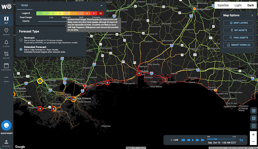
Road Closures: I-10 will see serious impacts, and closures are likely. The WeatherOptics Road Risk Index reaches extreme levels along I-10 from Slidell through Gulfport, Biloxi and Mobile to Pensacola by early Saturday, and on I-65 north of Mobile. We are seeing risk scores up to 10, which may make travel impossible at times and widespread road closures are anticipated.
Isolation: Some communities will be cut off from roads and communications during the peak of the storm Friday night.
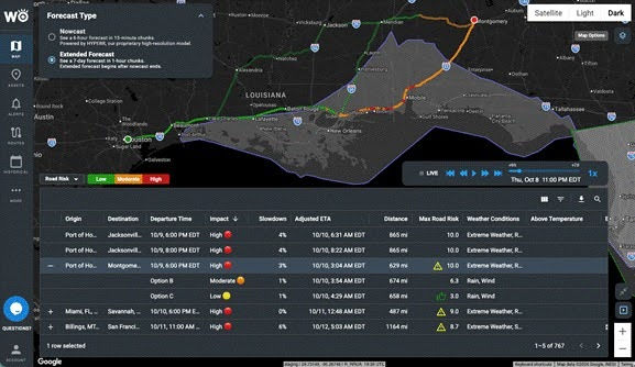
Freight: Loads crossing the I-10 corridor between Louisiana and the Florida Panhandle on Friday and Saturday face severe delays. The window to reroute or re-time is now, not Friday afternoon.
Here is what that looks like for a real lane. A load from the Port of Houston to Montgomery departing Friday at 6 PM ET reaches a maximum Road Risk of 10.0 on its primary route along I-10. WeatherOptics' RightRoute ranks the alternates: the best option drops the maximum risk to 3.0 for 29 extra miles and an arrival about 85 minutes later.
04 Widespread Power Outages
Damaging winds will bring down power lines across coastal Mississippi, Alabama and the Florida Panhandle. The WeatherOptics Power Outage Index expects 41–50% of customers to be affected in the hardest-hit areas around Mobile Bay early Saturday. Flooding and blocked roads will slow restoration, and recovery could take days or even weeks in the hardest-hit areas.

05 Life & Property Damage
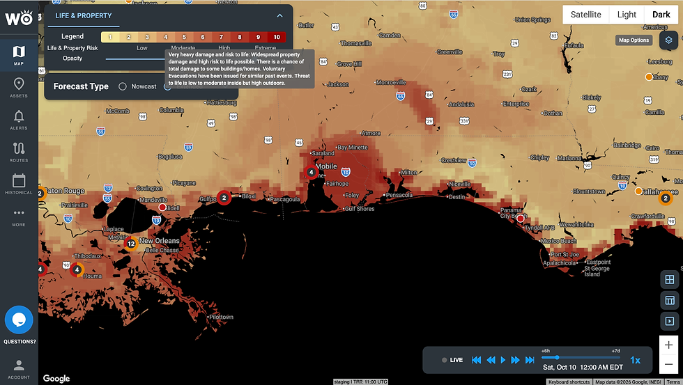
The WeatherOptics Life & Property Index shows very heavy damage and a high risk to life near the forecast landfall. Widespread property damage is possible, and voluntary evacuations have been issued for similar past events. This will be a dangerous, life-threatening storm.
What Enterprise Teams Should Do Now
This is the week weather plans get tested. Residents, emergency management and logistics operations need to make immediate preparations.
Lock in freight decisions by Today (10/8): Hold, reroute or re-time loads crossing I-10 between Louisiana and the Florida Panhandle on Friday and Saturday.
Map your exposure: Check warehouses, stores, ports, airports and other facilities in Mississippi, Alabama and the Florida Panhandle against the flood, wind and power forecasts.
Plan for outages: Confirm backup power and fuel for critical sites, and protect cold-chain inventory.
Protect your people: Move drivers and staff out of surge zones before Friday, and follow local evacuation orders closely.
Communicate early: Tell customers and partners now which shipments and services are at risk.
Plan for recovery: Roads and power may take days or weeks to return. Stage people and supplies just outside the impact zone.
Now is the time to act. Hopefully, the forecast improves.


Comments